More running! Seem to be doing a lot of it, the more I do the more Ienjoy it. Still not fast, but it is getting less painful.
Must remember to get out on my bike though!
So rather nippy this morning, because it is probably the first real freeze this year, there is no salt or grit out.
-3 in Westhill this morning. Ice everywhere, slippy as hell.
Didn’t manage to get to work without leaving part of my buttock on the road.
Love commuting in the winter! Think I might invest in some metal spike tyres! Sorry about the pictures

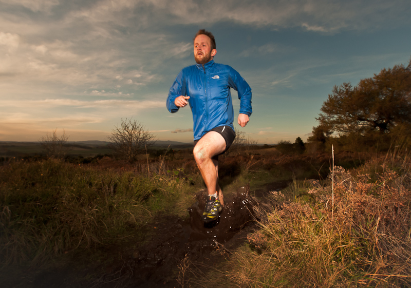
A little while ago, for some reason that has escaped me, I entered a half marathon. I have no delusions of being a good runner, in fact I am pretty much the complete opposite! My legs are conditioned for biking. Running uses pretty much the opposite muscles in the legs than cycling do.
I was keen to get out and do some running, having suffered from a bad back the last two weeks, I did not want to get out and run too far so that I did not re-agitate my back. I asked Matt if he wanted to come along as well and keep me company (Matt has started running recently as Emma is doing the half marathon with me so he is running with her)
We chose Durris Hill as I fancied running off road and it was half way in between our houses. I had a quick look at some maps online and had drawn out a route that was roughly 6-8km. I sold Matt on the idea and we met in the car park.

The above is the route I had drawn out. Because the 1:50’000 maps don’t show the paths I managed to print of a basic and poor quality 1:25’000. After the customary faffy in the car park we were off. We had both roughly committed the route to memory.
The sun was shining amazingly despite the rubbish forecast and off we went. we both have running GPS watches (not navigational) which tells every bit of information we could possibly want, so at regular intervals we were being geeks
“my heart rate is at 87% of the max, what is yours? Wow that is interesting Dave, mine is 86% of max, wow Matt we are really cool aren’t we” and on it went.
We got to one really steep hill, I being my normal stubborn self was not planning on giving up running up it, that was until I noticed Matt had started walking and was going the same pace as me. I conceded.
After a while it started to feel like we were making the map fit, things did not feel right. Oh well, lets just go a bit further and see if we can work it out. After about 5minutes of features that should have been appearing not, we had to do one of the hardest things known to man, it hurt us greatly. Like a knife to the side.
“I think we are lost”
My map I had printed was useless. We had to use our inbuilt man compasses. We roughly knew the direction we had parked the car and off we went running. The geeky heart rate max comparisons soon stopped and turned into “my knees hurt” “I am thirsty” “leave me, save yourself” “tell my family I love them” type conversations
Eventually we found our way out of the woods and worked out where we where when we hit the road. Below is a map of where we actually went with the original route drawn on for comparson.

So we ended up running just over 15kms. Pair of total and utter pillocks. We had to walk back along the road for another 4km to the car as our legs were shot. This was the longest both Matt and I had ever run. I am pretty dam stiff and sore writing this! But it has given me some more confidence for the half marathon in 3 weeks. Before I t hought I had no chance, now, I think I might actually have a chance in getting around!
Cheers Matt for not leaving me in the woods.
So after a quick navigational mishap and going to the wrong carpark, I was eventually corrected and we met Scott in the Car park atAuchallater only 30 minutes late. The plan for the day was for Euan, Scott B, Scott M and I do go for a ride in the hills.
The morning was lovely and it looked set to be a great day. We set off down Glen Callater. The first photo was taken and Burnett set off the trend of the day with ‘Gun shows’
As we rounded Loch Callater we had a rude awakening. The track went steeply up the hill. It was lung and leg bursting. I am pretty sure I heard Euan mention something about “a searing pain of oxygen debt”

The two Scotts (name and nationality) after the sharp 400m of altitude gain. At around 900m we unfortuntaly entered the cloud and that was our ideas of day long views out the window. We skirted along the Coire Loch Kander. The vis was low and I was glad I had my GPS

Eventually we found the top of Cairn of Claise our first Munro of the day. We sat there and ate some food. The clooud at one point did actually clear for about 30 seconds and then it came back again for the rest of the day.

A rather good ‘Gun Show’ Mr Burnett definitely has a talent at this. One I hope to learn off of him if he will take me under his wing and show me the way.
We set off East ish to navigate around the head of Glen Callater via Tolmount and Fafernie. It is also Stalking season at the moment and there was a lot of folk out with guns. No one was brave enough to stick some sticks in their helmets and charge off into the mist making deer noises to add the extra adrenaline kick!

This was a mixture of fun ‘off piste’ riding where we just went were the force was taking us and if it felt like it was generally in the right direction we would pick a line down it – or Peat bog pushing. Both were strangely good fun in a sick perverse sense.
From here we skirted over to Carin An Sagairt Mor (no idea how to say it) and from here the descent was brilliant. Hats off to Mr Muir for suggesting it

Was lots of rocky steps, tricky nagery (yes that is a technical term) and fast bits back out down the bottom of the could so after 3 and a bit of hours in the cloud we once again had a view.

We had three punctures on the descent, 1 mine, two Scott M’s and all within 300m of each other. We all got back down to the bottom smiling giggling idiots with the normal “that was brilliant” “did you manage to get over that rock ” etc. this followed a fast blast back down the fire road to the van and then home. A great day out of real mountain biking.
All the pictures can be seen if you CLICK HERE
Dad has always talked about wanting to walk the Pennine way, with him retiring this year it has given him the time to do it. So I thought it would be a great thing to do together as I would not mind doing this as well. In total it is 450 odd kms. Far to much to do one a oner. We decided to break it down smaller chunks to do at different weekends over the next year or so.

So here we are at the start of the trail in Edale in the Peak District out side the Nag’s Head. Dad and I about to set off. The forecast was pretty grim, wind and rain all day. But we are walking so shouldn’t be too bad! so off we went.
I have not really been to the Peak District since my uni days when Mr Raven and I used to come up here alot to bike, and I used to come up to climb with Raymond, so was great to see some of the old places and it certainly brought back some great memories of days we had up there.
We set off down the Vale of Edale and up Jacobs Ladder to Kinder Scout and to Kinder Low(633m) this is the highest hill in the peak district so nothing like breaking the old boy in gently! Dad actually did fine, after he stopped his interval walking (sprint then stop for a puff and set off sprinting again) he got into a rhythm and had no issues.

The weather forecast had it correct, but did not quite get the extent right. When it said rain – it was understating it. A more accurate description would have been biblical “quick all animals in pairs to the big boat” rain. With the rain was also 50mph winds. It was not pleasant but it was bearable. Above is just before Kinder Downfall, a strange waterfall which was going uphill due to the wind blowing the water up!
Soon dads boots started to pack in the notion that they are water proof and dad started a comical noise of ‘sloshing’ every foot step he took as his boots had puddles in them! we got just over half way and were faced with a choice. up and over Bleaklow which is another high exposed couple of hours or retreat down the William Clough gully to Hayfield.

We decided that we actually were not having a great deal of fun and this was suppose to be done for pleasure and it was not really ticking those boxes. We didn’t have any views all day and were drenched. On the OS map Hayfield had a pub on it…. easy choice really. We did just under 20km of the trail and was a good day and taught us a few things

We will be back next spring to carry on the trial. We know dad needs new boots and there is a mean curry house in Glossop!
The rest of the Photos can be seen if you CLICK HERE
